Lancaster's 3km flood wall project is "on time and programme" despite Covid-19 pandemic
and live on Freeview channel 276
Lancaster City Council said that work has been continuing on the Flood Risk Management Scheme to better protect the city from the effects of flooding despite the ongoing challenges faced by Covid-19.
The foundations for three sections of the 2.8km scheme have now been completed.
Advertisement
Hide AdAdvertisement
Hide AdThe first pre-cast wall unit was laid on March 9, and more than 550 units have now been installed equating to 40 per cent of the total number of units to be placed.
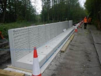

The scheme will provide 2.8km (1.7 Miles) of enhanced flood defences to provide protection from the River Lune and surface water flooding.
It aims to provide protection to homes and businesses on both banks of the River Lune - including 1,174 businesses, 2,000 jobs and 40 homes.
It is estimated that it will save £60m in costs associated with future flood damage.
Advertisement
Hide AdAdvertisement
Hide AdThree new trees will be planted for every one removed, Lancaster City Council has said, although this won't necessarily be in the same location.
Improvements to the flood defences are being made from the Holiday Inn at Junction 34 of the M6 motorway and finish at the A683, Skerton Bridge in Lancaster city centre.
On the north bank this includes enhanced flood mitigation in the Aldrens Lane area.
A Lancaster City Council spokesperson said: "Our work has been identified as essential by the government and they are keen for us to continue progressing, where it remains safe to do so.
Advertisement
Hide AdAdvertisement
Hide Ad"Our priority in these difficult times is the health, safety and wellbeing of our staff and the public, and additional safety measures have therefore been put in place.
"There has been understandably some impact on our supply chain, workforce and travel, however we expect at this stage to remain on time and programme."
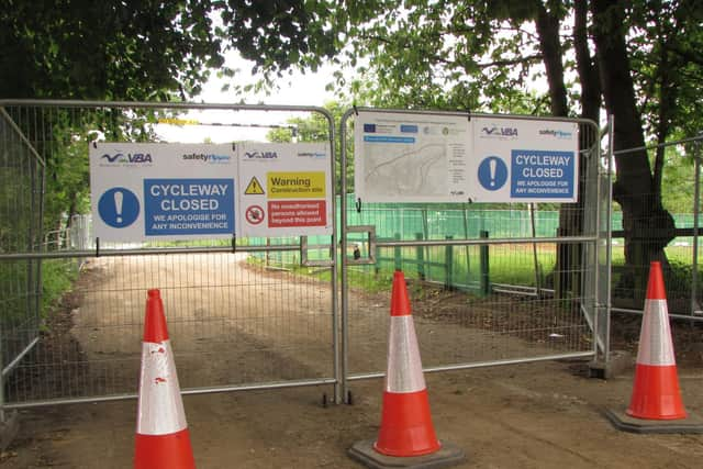
A temporary route for cyclists and pedestrians has been put in place along Caton Road, which has attracted some criticism from users.
In December 2015 Lancaster suffered extensive flooding including the flooding from the River Lune when existing defences were breached.
Advertisement
Hide AdAdvertisement
Hide AdDuring this period, flows of around 1,750 cubic metres per second - the highest flow ever recorded in an English river - were experienced immediately upstream.
This is the equivalent of filling an Olympic size swimming pool every one and a half seconds.
The flooding caused widespread damage to businesses and residential properties and caused major disruption to infrastructure.
This included the loss of power to around 60,000 properties due to the flooding of Caton Road sub-station.
Advertisement
Hide AdAdvertisement
Hide AdThere have been multiple flooding events following this event, testing the flood defences.
The work on the new defences started in January 2020 with most of it due to be completed early next year.
Additional landscaping and tree planting works will be taking place in Spring 2021.
The project cost is £10.8m, and is funded by the European Regional Development Fund as part of the European Structural and Investment Funds Growth Programme 2014-2020, the Environment Agency, the Local Levy from the Regional Flood and Coastal Committee, as well as contributions from Lancaster City Council and the private sector.
Advertisement
Hide AdAdvertisement
Hide AdIn relation to potentially worse flooding up or downstream as a result of the scheme, Lancaster City Council and its partners said: "Our hydraulic modelling shows that the Caton Road, Lancaster, flood defence scheme would not have any major impact on flood levels up or downstream of the River Lune.
"No modelling can be precise, and will contain margins of error.
"The modelling for this scheme shows that, potentially, flood depths up or downstream could be slightly higher during a 1% (1 in 100) year event by up to a maximum of 40mm (4cm) at the most.
"However, we allow for a modelling tolerance and it may be that flood levels up or downstream could actually remain the same as they are now.
Advertisement
Hide AdAdvertisement
Hide Ad"We have also validated what the model shows with actual flood events in Lancaster in 2015 and 2017 for example for accuracy."
The work is being undertaken by VBA Group (Volker Stevin, Boskalis Westminster, and Atkins).