Trails from the riverbank


In its middle section it is dominated by the huge bulk of Pendle Hill. This short walk will introduce you to a lovely reach of the river, with the great hill as a backdrop.
Directions: With the Three Fishes on your right, walk slightly downhill, passing the church and the Old Hall. Both church and hall have histories stretching back to antiquity. The road leads down to Mitton Bridge, which crosses the Ribble. From it there is a delightful view of the river.
Advertisement
Hide AdAdvertisement
Hide AdCross, passing the Aspinall Arms pub and then turn left through a wooden kissing gate. Close to this spot there is a sign showing that, from the start of the walk, you have been on the Ribble Way. This 70-mile Long Distance Path follows the Ribble from its source in the Yorkshire Dales to its estuary, near Longton to the west of Preston.
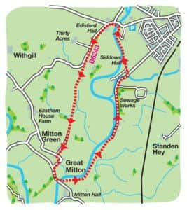
The footpath follows a fence on the left, and soon offers a splendid view of the church and hall across the river. Follow the field boundary as it leads gently uphill to a stile in a wooden fence. Over this bear left, and then after a kissing gate enter a large riverside pasture. Beyond a small service building join as riverside track leading up to a utility bridge spanning the river. Here, continue through a wooden gate on a track that soon brings you to Shuttleworth Farm.
After passing outbuildings on the right, go through a kissing gate to diagonally cross a small meadow to a second kissing gate in its far corner. Turn left onto the farm road. This lane separates you from the river in 500m. After the river bends away, keep ahead for another 500m to reach a junction immediately beyond woods on the left. Here turn left and the right onto a track a short distance from the junction. Almost immediately go through a kissing gate that leads to an enclosed path. This reunites you with the river.
The path passes close to a camping and caravanning site to enter the Riverside Park before Edisford Bridge. Keep ahead through the playground and car park to join Edisford Road (B6243). Turn left.
Advertisement
Hide AdAdvertisement
Hide AdThere is no pavement over the bridge, so be aware of traffic. Now keep firmly to the right side of the road as it climbs up past the Edisford Bridge Inn.
Keep on the main road past the junction for Balshall and continue for another 800m. The prominent height to the right is Longridge Fell. Where the road bends sharply right, cross to the drive of a farm. Turn right onto a farm road. After crossing a stile next to a metal gate, continue on the tarmac to the next gate. After this bear slightly right to cross a stile leading into a large field. Follow the hedge to your left as its leads you across fields by a series of wooden stiles.
After the way crosses a culvert, the next stile leads into a vast field. Keeping parallel to the hedge on the left cross this and then a short distance beyond a small, enclosed pond turn left over a stile onto a narrow path known as Malkin Lane. Keep on it for 300m until it brings you onto a quiet lane opposite a house. This is, in fact, Church Lane. Turn left and you’ll soon arrive in Great Mitton.
Walk devised by David Johnstone, secretary of the Norwest Fellwalking Club, and described by John Griffiths and Bob Clare. For an illustrated version, go to www.lancashirewalks.com
Advertisement
Hide AdAdvertisement
Hide AdStart/finish: Close to the Three Fishes Inn, Great Mitton, opposite Church Lane.
Distance: 6.5km (4½ miles)
Time: 1.5 to 2.5 hours
Summary: Flat and easy with a short climb away from the river at Edisford Bridge. After Edisford Bridge there is a road section of one kilometre (1,000 yards) Readers are advised to walk on the right, facing oncoming traffic.
Maps: OS OL 41 The Forest of Bowland.