Country trails: Stoops to conquer...


Another element has been the improvement of existing and the creation of new Landover tracks to provide amenity for the shooting fraternity.
Grouse shooting draws in considerable income into the local economy and the moors, despite their wild appearance, are seriously managed. This walk is one of the great Bowland expeditions, taking you from the attractive hamlet of Abbeystead up to Bowland’s highest point before returning on the Wyre Way.
Advertisement
Hide AdAdvertisement
Hide AdDirections: 1. From the car park turn left across Stoops Bridge and the infant River Wyre. On the far side turn right on to a footpath opposite a handsome house. Keep on it as it crosses riverside meadows to reach Rakehouse Brow.
Turn left. After 300yds bear right on to the farm drive of Rakehouse Barn. Follow the track as it bears right in front of another handsome house (Higher Lee) and then turns left to commence the climb up to Grizedale Head.
This Landover track provides very easy walking and navigating. Two miles – almost an hour’s walking – the track levels out and then intercepts the ridge route between Grit Fell to the left and Ward’s Stone to the right.
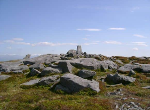
2. Turn right. This path is of a very different character to the Landover track. As it crosses peat and heather it begins to climb along a shallow rock strewn gully to reach the first of two trig. points. Here there is an impressive gritstone outcrop that presumably gave the fell its name. Maintaining the same direction of travel from Grit Fell i.e. eastwards, look for the second trig point on the horizon. A boundary stone will be passed after 150yds or so. After reaching the second trig point, at 561m one metre higher than the first, drop down on a more definite path to the corner of a fence.
Advertisement
Hide AdAdvertisement
Hide AdThis fence now provides a handrail to guide you over the next section of the route. On two stretches the fence becomes a wall. Keep the fence/wall on your left as you progress along the broad ridge moving closer to the next summit, Wolfhole Crag.
3. In this way you will intercept a Landover track that crosses your path, a mile and a half from the second trig point. Turn right.
Follow the track as it winds its way down the fellside and after an hour after joining it, you will arrive at the tiny settlement of Tarnbrook.
4. After entering the hamlet keep ahead on the main street for 150yds and then turn left on to a footpath that is the Wyre Way. This trail leads most of the way back to the car park. First it crosses the Tarnbrook Wyre and then climbs the low ridge through a succession of fields to Top of Emmetts. The path is well signed with waymark arrows and decorative stone markers. When Top Emmetts comes into sight across a large field turn left and cross a ladder stile followed by a footbridge into the adjoining field. Turn right and, with the hedge on your right, keep ahead to reach the drive of Top Emmetts.
Advertisement
Hide AdAdvertisement
Hide AdCross the lane and follow the footpath in the direction of Strait Lane.
After a marker stone, decorated with a bunny rabbit, bear left in the huge field to follow the side of a plantation to a gate behind a property. The path leads through an enclosure, around a shed and on to Strait Lane. Turn left for Stoops Bridge.
• Walk devised by Malcolm McCulloch, one of the Usual Suspects, and described by Bob Clare. For more walks see www.lancashirewalks.com.