Beacon walk will relight your fire


This walk allows you to do that - taking you along the lovely Brock valley and across the Vale of Bleasdale with outstanding views of the Bowland Fells.
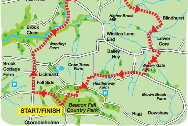
Directions: Continue along the fell road for 300m to a point where it is crossed by a footpath. Here, turn left, following the path through a memorial forest and then continuing downhill crossing a footbridge at the bottom of the slope. Keep ahead to reach a lane (Bleasdale Road). Turn right.
Advertisement
Hide AdAdvertisement
Hide AdKeep on the lane for 900m, quickly passing White Lees Lane end. Where the road bends sharply right, continue on Jack Snape Lane, turning right after 200m into the grounds of Waddecar Scout Activity Centre.
Many readers with childhood links with the Scout/Guide movement in Lancashire will be familiar with this facility.
Keep on the drive to reach Wood Top Farm. Keep ahead through the yard, which doglegs left then right, passing through a pair of gates. Immediately after these turn left through a metal gate entering a garden area of Waddecar.
Cross to a footpath leading steeply downhill to the valley bottom of the River Brock. For the next 1,000m keep the river on the left. After 500m, cross a footbridge and soon after climb a steep slope to reach open fields.
Advertisement
Hide AdAdvertisement
Hide AdFollow the fence on the left for 200m before crossing it to enter briefly New Bridge Wood. Now, with the fence on your right, continue to reach Bleasdale Road. Turn right. Almost immediately, turn left through Weavers Farm and keep ahead through the complex to reach a farm track entering fields.
Keep ahead after the track peters out in the direction of Bleasdale Church. When you reach a lane turn right. At the junction close to Bleasdale Primary School, keep ahead on a path leading across pasture to a patch of woodland. Through this, after a kissing gate, keep ahead to join a farm road close to a green birdwatchers’ hide.
Turn left, but soon after turn right on a footpath that soon after crosses the infant River Brock by a footbridge. Bear left, crossing a wall, and continue to join a farm track leading uphill to Blindhurst. Behind Blindhurst Parlick looms.
At Blindhurst, dogleg right and then left and then turn right again onto the main farm drive, leading out to Startifants Lane some 800m, or 10 minutes, from the farm. At the lane turn left, and after 150m turn right onto a footpath that diagonally traverses a large field to a stile. (Follow the direction of the signpost).
Advertisement
Hide AdAdvertisement
Hide AdCross the stile, and with a fence on the right keep ahead past a plantation and continue to reach a lane close to a large piece of real estate.
Turn right, past the front of the house and continue to the lane corner where it bends to the right. Walk up the drive towards Wood Acre and then turn right over a stile and continue past the property on the left to a second stile. Over this, keep ahead across pastureland with fencing on the right.
Close to a plantation, join a drive leading past Sagar’s Farm to reach a farm road. Turn left towards Heatherway, but before you reach the main house turn right onto a footpath that edges along marshy pasture.
After 100m, turn right onto a path leading uphill towards Beacon Fell. When you reach the fell road, cross it to continue through plantations to the open fell. Keep ahead for the car park, or else divert to the trig point for a fine view of the way you came.
Advertisement
Hide AdAdvertisement
Hide AdStart/finish: Beacon Fell Bowland Visitor Centre Pay & Display car park
Distance: 9km (5.5 miles)
Time: 2.5 – 3.5 hours
Summary: Moderate
Maps: OS OL 41 The Forest of Bowland
Walk devised by David Johnstone secretary of the Norwest Fellwalking Club and described by John Griffiths and Bob Clare. For an illustrated version of this walk, go to www.lancashirewalks.com